<p>Yes, the basic UML is it, very clean:</p>
<p><a href="https://wiki.openstreetmap.org/wiki/File:UMLclassOf-osm2pgsql-schema.png"><img src="https://camo.githubusercontent.com/f6c2e5d0f049d7b50a51cef765fb803eb0aa5c8e/68747470733a2f2f77696b692e6f70656e7374726565746d61702e6f72672f772f696d616765732f622f62662f554d4c636c6173734f662d6f736d32706773716c2d736368656d612e706e67" alt="" data-canonical-src="https://wiki.openstreetmap.org/w/images/b/bf/UMLclassOf-osm2pgsql-schema.png" style="max-width:100%;"></a></p>
<p>As all illustrations, have its power of summarize and consolidate information... In this case, using UML, it is also a <strong>standard summarization</strong>, for any one that never see OSM maps or osm2pgsql.</p>
<p>... I will review (the complex) Wiki documentation and community's <a href="https://wiki.openstreetmap.org/wiki/Osm2pgsql/schema">Osm2pgsql/schema</a> perspective... them back here with a good and final suggestion. Perhaps proposing something to "syncronize documentations".</p>
<hr>
<p>PS: there are a project that exports (or check or report) the <a href="https://en.wikipedia.org/wiki/DE-9IM">spatial relations</a> and "consistence constraints"? Example: all 5570 <a href="https://en.wikipedia.org/wiki/Municipalities_of_Brazil">municipalities of Brazil</a> in <em>osm_polygon</em> must be into (by <a href="http://www.postgis.org/docs/ST_Contains.html">ST_Contains</a>) a <a href="https://en.wikipedia.org/wiki/States_of_Brazil">states of Brazil</a> of <em>osm_polygon</em>.</p>
<p style="font-size:small;-webkit-text-size-adjust:none;color:#666;">—<br />You are receiving this because you are subscribed to this thread.<br />Reply to this email directly, <a href="https://github.com/openstreetmap/osm2pgsql/issues/671#issuecomment-271840779">view it on GitHub</a>, or <a href="https://github.com/notifications/unsubscribe-auth/AD2-7hz8lGWtWFSMaRkuJutipqiveB5qks5rRLcXgaJpZM4Lf6DF">mute the thread</a>.<img alt="" height="1" src="https://github.com/notifications/beacon/AD2-7sigDM72cCn6o1h3zMrN2ELskt6fks5rRLcXgaJpZM4Lf6DF.gif" width="1" /></p>
<div itemscope itemtype="http://schema.org/EmailMessage">
<div itemprop="action" itemscope itemtype="http://schema.org/ViewAction">
<link itemprop="url" href="https://github.com/openstreetmap/osm2pgsql/issues/671#issuecomment-271840779"></link>
<meta itemprop="name" content="View Issue"></meta>
</div>
<meta itemprop="description" content="View this Issue on GitHub"></meta>
</div>
<script type="application/json" data-scope="inboxmarkup">{"api_version":"1.0","publisher":{"api_key":"05dde50f1d1a384dd78767c55493e4bb","name":"GitHub"},"entity":{"external_key":"github/openstreetmap/osm2pgsql","title":"openstreetmap/osm2pgsql","subtitle":"GitHub repository","main_image_url":"https://cloud.githubusercontent.com/assets/143418/17495839/a5054eac-5d88-11e6-95fc-7290892c7bb5.png","avatar_image_url":"https://cloud.githubusercontent.com/assets/143418/15842166/7c72db34-2c0b-11e6-9aed-b52498112777.png","action":{"name":"Open in GitHub","url":"https://github.com/openstreetmap/osm2pgsql"}},"updates":{"snippets":[{"icon":"PERSON","message":"@ppKrauss in #671: Yes, the basic UML is it, very clean: \r\n\r\n[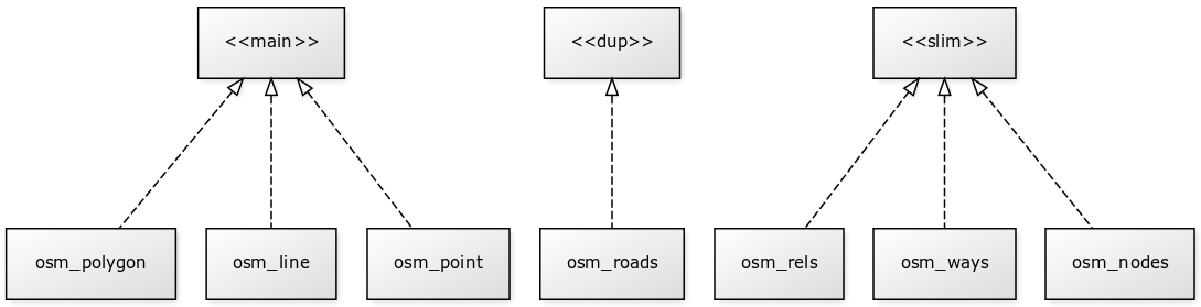](https://wiki.openstreetmap.org/wiki/File:UMLclassOf-osm2pgsql-schema.png)\r\n\r\nAs all illustrations, have its power of summarize and consolidate information... In this case, using UML, it is also a **standard summarization**, for any one that never see OSM maps or osm2pgsql.\r\n\r\n... I will review (the complex) Wiki documentation and community's [Osm2pgsql/schema](https://wiki.openstreetmap.org/wiki/Osm2pgsql/schema) perspective... them back here with a good and final suggestion. Perhaps proposing something to \"syncronize documentations\".\r\n\r\n-----\r\n\r\nPS: there are a project that exports (or check or report) the [spatial relations](https://en.wikipedia.org/wiki/DE-9IM) and \"consistence constraints\"? Example: all 5570 [municipalities of Brazil](https://en.wikipedia.org/wiki/Municipalities_of_Brazil) in *osm_polygon* must be into (by [ST_Contains](http://www.postgis.org/docs/ST_Contains.html)) a [states of Brazil](https://en.wikipedia.org/wiki/States_of_Brazil) of *osm_polygon*.\r\n\r\n\r\n"}],"action":{"name":"View Issue","url":"https://github.com/openstreetmap/osm2pgsql/issues/671#issuecomment-271840779"}}}</script>