<blockquote>
<p>both the Egypt and Eritrea boundary relations were fine according to JOSM validator.<br>
So why were those missing as well? Is this a potential issue in osm2pgsql, or an issue with the Africa extract?</p>
</blockquote>
<p>my suggestion: check the "Africa extract" first,</p>
<p>For example Eritrea - Geofabrik extract Poly - smaller than the admin_level=2 border<br>
<a target="_blank" rel="noopener noreferrer" href="https://user-images.githubusercontent.com/2217320/55902217-5390d480-5bcb-11e9-93ea-aeb03a272f44.png"><img src="https://user-images.githubusercontent.com/2217320/55902217-5390d480-5bcb-11e9-93ea-aeb03a272f44.png" alt="image" style="max-width:100%;"></a></p>
<p>And the same - in the Africa Geofabrik extract Poly.<br>
<a target="_blank" rel="noopener noreferrer" href="https://user-images.githubusercontent.com/2217320/55902556-137e2180-5bcc-11e9-8e3c-35e6b9f265f7.png"><img src="https://user-images.githubusercontent.com/2217320/55902556-137e2180-5bcc-11e9-8e3c-35e6b9f265f7.png" alt="image" style="max-width:100%;"></a></p>
<p>imho: for the borders ( admin_level=2 ) - the planet file is the best.</p>
<p style="font-size:small;-webkit-text-size-adjust:none;color:#666;">—<br />You are receiving this because you are subscribed to this thread.<br />Reply to this email directly, <a href="https://github.com/openstreetmap/osm2pgsql/issues/926#issuecomment-481801785">view it on GitHub</a>, or <a href="https://github.com/notifications/unsubscribe-auth/AD2-7i_CduwDdXZDPvKasvnrmihvgvGGks5vfikEgaJpZM4cmZ_C">mute the thread</a>.<img src="https://github.com/notifications/beacon/AD2-7tLYpsusHmZ7uDEkuuIg-6PXfheFks5vfikEgaJpZM4cmZ_C.gif" height="1" width="1" alt="" /></p>
<script type="application/json" data-scope="inboxmarkup">{"api_version":"1.0","publisher":{"api_key":"05dde50f1d1a384dd78767c55493e4bb","name":"GitHub"},"entity":{"external_key":"github/openstreetmap/osm2pgsql","title":"openstreetmap/osm2pgsql","subtitle":"GitHub repository","main_image_url":"https://github.githubassets.com/images/email/message_cards/header.png","avatar_image_url":"https://github.githubassets.com/images/email/message_cards/avatar.png","action":{"name":"Open in GitHub","url":"https://github.com/openstreetmap/osm2pgsql"}},"updates":{"snippets":[{"icon":"PERSON","message":"@ImreSamu in #926: \u003e both the Egypt and Eritrea boundary relations were fine according to JOSM validator. \r\n\u003eSo why were those missing as well? Is this a potential issue in osm2pgsql, or an issue with the Africa extract?\r\n\r\nmy suggestion: check the \"Africa extract\" first,\r\n\r\nFor example Eritrea - Geofabrik extract Poly - smaller than the admin_level=2 border\r\n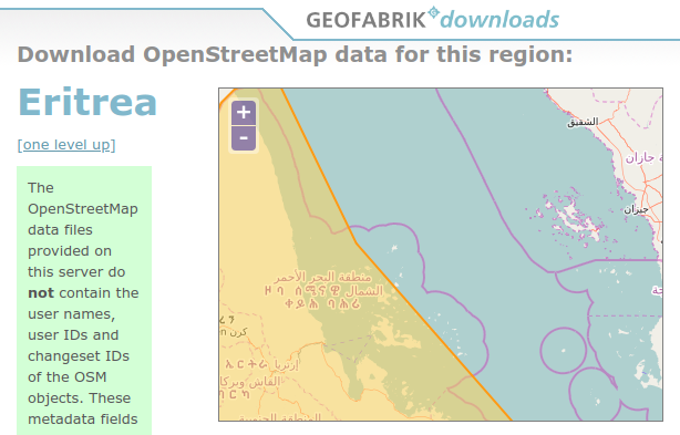\r\n\r\nAnd the same - in the Africa Geofabrik extract Poly.\r\n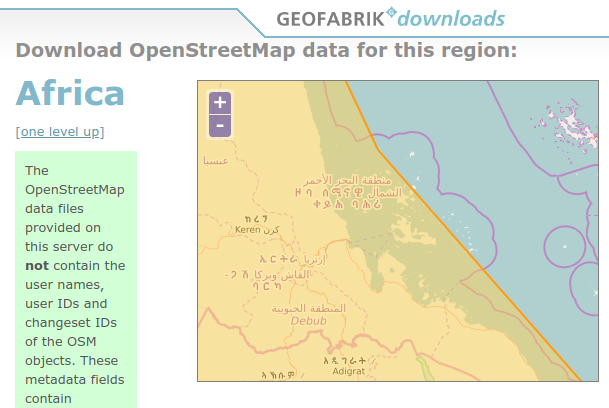\r\n\r\nimho: for the borders ( admin_level=2 ) - the planet file is the best.\r\n"}],"action":{"name":"View Issue","url":"https://github.com/openstreetmap/osm2pgsql/issues/926#issuecomment-481801785"}}}</script>
<script type="application/ld+json">[
{
"@context": "http://schema.org",
"@type": "EmailMessage",
"potentialAction": {
"@type": "ViewAction",
"target": "https://github.com/openstreetmap/osm2pgsql/issues/926#issuecomment-481801785",
"url": "https://github.com/openstreetmap/osm2pgsql/issues/926#issuecomment-481801785",
"name": "View Issue"
},
"description": "View this Issue on GitHub",
"publisher": {
"@type": "Organization",
"name": "GitHub",
"url": "https://github.com"
}
}
]</script>