[openstreetmap/openstreetmap-website] Strange rendering of suburb name over town name in CycleMap layer at low zoom levels (#3255)
Michael Collinson
notifications at github.com
Mon Jul 12 20:35:25 UTC 2021
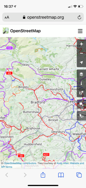
The screen shot below show a place=suburb "Garnett Wharfe" apparently rendering as a town and, the reason for reporting, replacing the town "Otley" of which it is a part. Neither node have been editted in several years.
At this view coordinates, the rendering of "Garnett Wharfe" behaves erratically at different zoom levels only in the CycleMap layer:
https://www.openstreetmap.org/node/4954984826#map=13/53.9102/-1.6894&layers=C Bad - Cycle Map
https://www.openstreetmap.org/node/4954984826#map=13/53.9102/-1.6894 Good - standard layer
Here are the nodes:
https://www.openstreetmap.org/node/4954984826 "Garnett Wharfe"
https://www.openstreetmap.org/node/20940471 "Otley"
https://www.openstreetmap.org/node/2354936300 "Newall" (another suburb which is well behaved)
https://www.openstreetmap.org/node/27402102 "Weston Estate" (another suburb which is well behaved)
The only other explanation I can think of is that someone added then deleted entirely different node and we are seeing the residual effects of that in cache.
Thanks, Mike Collinson
--
You are receiving this because you are subscribed to this thread.
Reply to this email directly or view it on GitHub:
https://github.com/openstreetmap/openstreetmap-website/issues/3255
-------------- next part --------------
An HTML attachment was scrubbed...
URL: <http://lists.openstreetmap.org/pipermail/rails-dev/attachments/20210712/de4d230a/attachment.htm>
More information about the rails-dev
mailing list