[Tile-serving] [openstreetmap/osm2pgsql] Schema and/or UML illustrations (#671)
Peter
notifications at github.com
Wed Jan 11 11:03:51 UTC 2017
Yes, the basic UML is it, very clean:
[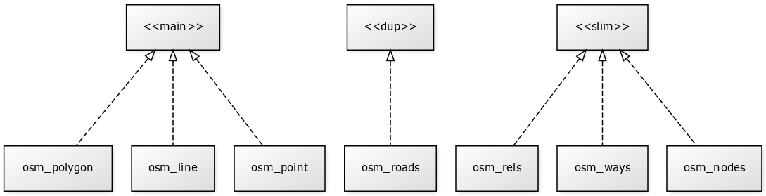](https://wiki.openstreetmap.org/wiki/File:UMLclassOf-osm2pgsql-schema.png)
As all illustrations, have its power of summarize and consolidate information... In this case, using UML, it is also a **standard summarization**, for any one that never see OSM maps or osm2pgsql.
... I will review (the complex) Wiki documentation and community's [Osm2pgsql/schema](https://wiki.openstreetmap.org/wiki/Osm2pgsql/schema) perspective... them back here with a good and final suggestion. Perhaps proposing something to "syncronize documentations".
-----
PS: there are a project that exports (or check or report) the [spatial relations](https://en.wikipedia.org/wiki/DE-9IM) and "consistence constraints"? Example: all 5570 [municipalities of Brazil](https://en.wikipedia.org/wiki/Municipalities_of_Brazil) in *osm_polygon* must be into (by [ST_Contains](http://www.postgis.org/docs/ST_Contains.html)) a [states of Brazil](https://en.wikipedia.org/wiki/States_of_Brazil) of *osm_polygon*.
--
You are receiving this because you are subscribed to this thread.
Reply to this email directly or view it on GitHub:
https://github.com/openstreetmap/osm2pgsql/issues/671#issuecomment-271840779
-------------- next part --------------
An HTML attachment was scrubbed...
URL: <http://lists.openstreetmap.org/pipermail/tile-serving/attachments/20170111/d69d9926/attachment-0001.html>
More information about the Tile-serving
mailing list